top of page

News & Announcements
Meteorology


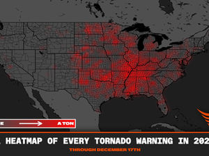
2025 Tornado Warning Heat Map
by Reed Timmer at https://www.facebook.com/reedtimmer2.0 Check out this 2025 TORNADO WARNING HEAT MAP that shows where the severe weather and threats stacked up during the season! In summary, over 8,000 tornado warnings were issued, a majority of which stem from the active Dixie Alley #tornado season to begin spring, with La Nina in concert with a warm-phase North Pacific Oscillation. This lead to a progressive upper-level storm track which pushes the instability and wind she
Mark Armstrong
1 min read


Cold Weather Events
When discussing extreme cold weather events, humidity shifts from being a "discomfort factor" to a primary driver of atmospheric energy and hazardous conditions. While arctic air is naturally dry, the interaction between this frigid air and moisture sources is what transforms a simple cold snap into a life-threatening winter storm. In the context of weather prediction, moisture is the "fuel" for extreme events. Meteorologists look for the interaction between a cold air mass,
Mark Armstrong
2 min read


Flash Flooding
Flash floods are among the deadliest weather phenomena in the United States, characterized by their rapid onset and extreme water flow. Defined as floods that occur within six hours, and often within minutes, of excessive rainfall, a dam or levee failure, or a sudden release from an ice or debris jam, they leave little time for warning or preparedness. These powerful torrents can roll boulders, tear out trees, destroy infrastructure like buildings and bridges, and are respons
Mark Armstrong
2 min read


What is a Mesocyclone?
A mesocyclone is a large, rotating column of air inside a thunderstorm, typically associated with supercell thunderstorms. It is a storm-scale feature that can be 2-6 miles wide and is the source of rotation for a tornado. Detected by Doppler radar, a mesocyclone indicates the potential for severe weather, including large hail, strong winds, and tornadoes. How a Mesocyclone Forms Horizontal Rotation : Wind at different altitudes changes speed and direction, creating a horizon
Mark Armstrong
1 min read


Tornadoes and Road Safety
When it comes to road safety during a tornado, the National Weather Service (NWS) emphasizes that a motor vehicle is the least desirable place to be, as cars, buses, and trucks are easily lifted and tossed by tornado winds. The NWS strongly advises people to never attempt to outrun a tornado in a vehicle. If a tornado is spotted or a warning is issued while driving, the recommended course of action is to drive immediately to the closest sturdy building or designated shelter.
Mark Armstrong
1 min read


Tornado vs. Straight-Line Winds: The Critical Difference Between Two Severe Threats
When a severe thunderstorm tears through a community, the immediate question is often, "Was it a tornado?" While tornadoes command attention for their rotational fury and extreme wind speeds, the truth is that much of the widespread destruction attributed to severe weather—including downed trees and flattened structures—is actually caused by a less publicized, non-rotating phenomenon: straight-line winds . Meteorologists with the National Weather Service (NWS) spend significa
Mark Armstrong
3 min read


What is a Derecho?
A derecho is a powerful, widespread, and long-lived storm characterized by destructive, straight-line winds, often exceeding hurricane-force speeds . The term "derecho" comes from the Spanish word for "straight ahead," describing the straight-line nature of the wind damage, contrasting with the rotating winds of a tornado. To be classified as a derecho, a storm must produce a wind damage swath extending at least 240 miles (400 km) long, with wind gusts of 58 mph (93 km/h) or
Mark Armstrong
2 min read


MRES Volunteers: The Critical On-the-Ground Eyes of the NWS SKYWARN Program
With the average lead time for a tornado warning at just 13 minutes, the real-time observations of Managed Radio Emergency Services (MRES) trained volunteers, acting as National Weather Service (NWS) SKYWARN spotters, are essential for providing the public with life-saving information.
Mark Armstrong
2 min read


Cloud Formations
A cumulus cloud is a detached, dense, puffy cloud with a flat base and rounded, cauliflower-like top, formed by upward-moving air currents . The name "cumulus" comes from the Latin word for "heap," describing the accumulated appearance of these clouds. They can indicate fair weather or develop into larger "towering cumulus" (cumulus congestus) or even rain-producing cumulonimbus clouds. Key Characteristics Appearance: Puffy, cotton-like, or resembling a cauliflower. Shape
Mark Armstrong
1 min read


Emergency Communication in Hurricane Preparedness
Hurricane season brings uncertainty and fear for many communities, especially for those in high-risk zones. As weather watchers and storm...
Mark Armstrong
2 min read
bottom of page
